Mappoint
Advertisement

F30 MapPoint North America v.2013
FREE THIRTY DAYS See your business in a whole new way.
Advertisement
GridImp
Imports gridded data into MS-MapPoint, to produce attractive data maps. Can handle imperfect data, holes, re-gridding, etc. Can be used to import such attributes as pollution data, seismic hazard, geological information, customer/population
MileCharter
Calculate Mileage Charts and Tables with Microsoft MapPoint. Calc. tables for serving customers and suppliers, or to create "road atlas" tables. Destinations can also be sorted with only the closest being reported. Can output distances, travel times

Back and Forward Utility
The back and forward view change buttons were removed in MapPoint 2009. The Back and Forward Utility implements this functionality as two menu items on the Tools menu. Users can now move back to previous map views, or move forward returning to the start
MPMileage v.2.1
Batch calculate distances, travel times, and/or costs for point-to-point routes listed in a database (Access, Excel, or ODBC). Uses MapPoint for point locations and route calculations. Supports all of MapPoint's route options.

MPCluster v.2.0
Microsoft MapPoint add-in that performs cluster analysis on MapPoint datasets. Clusters can be drawn as map annotation (centroid pushpins and/or cluster boundary shapes) and exported to Microsoft Excel. Supports a range of size options.
MPRouteWriter v.3.4
Imports and Exports MapPoint waypoints and pushpins in route-order. MapPoint always re-arranges pushpins when it does this. Exports routes directly to Excel or a text file; or you can create a route from pushpins in a pre-determined order.
OptiXL Distance and Time Calculator v.1 3
The OptiXL Distance and Time Calculator is an add-in for Microsoft MapPoint that will automate the calculation of driving distance and time between many locations and export the result to a Microsoft Excel workbook or a Microsoft Access database.
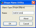
Shape Name Utility v.1.0
Freeware add-in tool for Microsoft MapPoint. Allows a user to view a shape's name and modify it if necessary. Also reports the shape type, and can query (but not modify) pushpin names.

Add-in Express 2 .NET Edition v.2.2.1751
It is a true RAD tool for creating COM Add-ins, Smart Tags and RTD on .NET. Add-in Express supports all host applications from MS Office Family such as Outlook, Excel, Word, PowerPoint, Access, Visio, FrontPage, Project, MapPoint and Publisher.

Add-in Express 2007 for VCL
Develop application-level COM add-ins, smart tags, RTD servers and user-defined functions. Write add-in code once and have it work across Microsoft Office 2000 through 2007. Create application-specific plugins and shared extensions that work on all